


GPS Area Measure On Map
Description of GPS Area Measure On Map
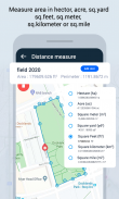
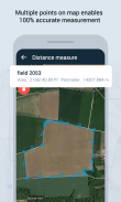
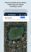
GPS Area Measure is an application designed for measuring fields, plots, route distances, and land surveys. This tool is particularly useful for agricultural purposes, gardening, and fencing on farms. Users can effortlessly measure distances and areas by placing multiple accurate points on the map, making it an efficient solution for various outdoor activities. The app is available for the Android platform, allowing users to easily download it and access its functionalities.
The app provides users with the ability to measure distances in various units, including meters and kilometers. This flexibility ensures that users can work with the measurement units they are most comfortable with. Additionally, when it comes to area measurement, the app supports multiple units such as square meters and yards. This feature is particularly beneficial for those involved in agriculture or landscaping, where precise area calculations are often required.
Users can also calculate the perimeter of specific areas, which adds another layer of utility to the app. By saving measurements with points on maps, users can drag and drop these points to refine their calculations. This smoothening feature ensures that users can accurately set points for their measurements, providing a reliable way to assess land sizes.
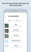
Editing saved measurements is another practical aspect of GPS Area Measure. If users need to adjust their previously recorded areas or distances, they can do so easily within the app. This feature is valuable for professionals who may need to revisit and modify their measurements based on changing conditions or requirements.
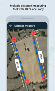
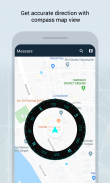
A compass display is integrated into the app, allowing users to check directions while measuring areas. This addition enhances the app's functionality, ensuring that users can orient themselves accurately while working outdoors. The precise pin-placement capability further complements this feature, as users can accurately mark locations on the map.
The app includes a Land Area Calculator, which offers two distinct methods for calculating land area. The first method, Custom Area Calculation, allows users to select the number of sides (three sides, four sides, etc.) to determine the area. This flexibility is useful for irregularly shaped plots of land. The second method, Shape Area Calculation, enables users to select predefined shapes such as squares, trapezoids, or triangles for area calculations. This feature not only simplifies the measuring process but also includes relevant formulas to help users understand the calculations involved.
GPS Area Measure is not limited to agricultural or construction applications. It also serves as a map measurement tool for outdoor activities, making it suitable for sports like biking or marathons. Whether planning a route or assessing a field for planting, users find this app beneficial for various scenarios.
For those engaged in construction projects, the app provides essential tools for measuring land accurately. The ability to obtain precise measurements ensures that users can plan their projects effectively, avoiding potential issues related to size calculations. Agricultural fencing becomes easier with the app, as users can measure areas to determine the appropriate amount of fencing material required.
The user interface of GPS Area Measure is designed to be intuitive, allowing users to navigate its features with ease. This accessibility makes it suitable for a wide range of users, from professional land surveyors to casual gardeners. The straightforward design ensures that individuals can quickly learn how to utilize the app's features without extensive training.
In addition to its core functionalities, GPS Area Measure is continuously updated to enhance user experience. The app developers focus on improving accuracy and adding new features based on user feedback. This commitment to improvement ensures that users have access to a reliable tool that meets their measuring needs.
The app's capacity to save measurements with points on the map is particularly advantageous for users who may need to revisit their data later. Whether for planning future projects or keeping records of measurements, this feature offers convenience and practicality.
By integrating various measurement tools, GPS Area Measure simplifies the process of assessing land and distances. Users can engage in outdoor activities, manage agricultural needs, and handle construction tasks with confidence, knowing they have an accurate measuring tool at their fingertips.
The combination of user-friendly features, accurate calculations, and versatile applications makes this app a valuable resource for many individuals and professionals. With its ability to cater to diverse measuring needs, GPS Area Measure stands out as an essential tool for anyone involved in land measurement or outdoor planning.
GPS Area Measure On Map - Version 1.15
(21-10-2024)GPS Area Measure On Map - APK Information
APK Version: 1.15Package: com.marathon.gps.fieldareaLatest Version of GPS Area Measure On Map
Other versions


 4.28
4.28
 4.63
4.63


Apps in the same category


